Storm Eowyn to Batter UK with 80mph Winds and Heavy Rain
The UK is bracing for its first named storm of 2025, Storm Eowyn, which is forecast to bring disruptive winds, heavy rain, and potential snow to the country this weekend. Originating from the turbulent weather systems over the Atlantic, Storm Eowyn is expected to make landfall on Friday, impacting nearly the entire UK, with the exception of London and East Anglia. The storm’s intensity is anticipated to peak on Friday, with wind gusts potentially exceeding 80mph in exposed coastal regions of Northern Ireland, northern England, northwestern Wales, and western Scotland. This poses a significant risk of damage to buildings, power outages, and flying debris.
The Met Office has issued yellow weather warnings for wind covering most of the UK on Friday. By Saturday, these warnings will be largely confined to Scotland, although strong gusts of 50-70mph are still anticipated, particularly in coastal and hilly areas. Disruptions to travel are also likely, affecting airports, ferries, railways, and roads. The strong winds will be accompanied by heavy rain, particularly in western regions of Scotland, England, and Wales, where rainfall accumulations of 20-30mm are possible. Higher elevations in the northern half of the country, especially the Scottish mountains, might experience snowfall.
The dramatic shift in weather conditions is attributed to a large mass of extremely cold air over North America, which is creating a stark temperature contrast across the continent. This contrast intensifies the jet stream, leading to the formation of deeper low-pressure systems that are then propelled towards the UK by the jet stream. This interaction between the North American cold air mass and the Atlantic weather systems underscores the interconnectedness of global weather patterns.
The intensity of Storm Eowyn has prompted the Met Office to issue early warnings, urging the public to stay updated on the evolving forecast. The potential for widespread disruption necessitates proactive preparations by individuals, businesses, and emergency services. The combination of high winds and heavy rain creates a particularly hazardous situation, emphasizing the importance of safety precautions.
While the strongest winds are expected to impact western and northern regions, the heavy rain will affect a wider area. The combination of strong winds and heavy rain could lead to localized flooding, particularly in areas with poor drainage. The potential for snowfall in northern areas adds another dimension to the potential impact, particularly for transportation.
The Met Office is closely monitoring the development and trajectory of Storm Eowyn, refining the forecast as more data becomes available. This vigilance is crucial for providing timely and accurate information to the public, enabling them to take necessary precautions. The early issuance of warnings allows individuals and communities to prepare for the potential impacts of the storm, including securing loose objects, stocking up on essential supplies, and planning alternative travel arrangements. Staying informed about the latest weather updates is paramount for minimizing disruption and ensuring personal safety during this period of unsettled weather. The potential for power outages further underscores the need for preparedness, including having alternative light sources, communication devices, and heating options.
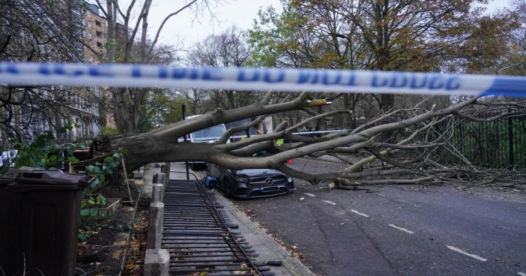
The UK experienced similar stormy conditions in November 2024 with Storm Bert, which caused widespread damage, including a parked car being crushed by a fallen tree. Such incidents serve as a stark reminder of the destructive power of severe weather events and the importance of heeding warnings and taking precautionary measures. The frequency and intensity of storms like Eowyn highlight the ongoing impact of climate change on weather patterns and the growing need for resilience in the face of extreme weather conditions. The anticipated disruptions caused by Storm Eowyn will likely have economic consequences, affecting businesses, transportation networks, and emergency services.
The Met Office’s use of named storms aims to raise public awareness about severe weather events and encourage proactive measures. The name "Eowyn" is taken from a pre-approved list, which follows a specific naming convention. This systematic approach to naming storms facilitates clear communication and enhances public understanding of the potential risks associated with each event.
The UK’s vulnerability to Atlantic storms necessitates ongoing investment in weather forecasting capabilities, infrastructure resilience, and public awareness campaigns. These measures are essential for mitigating the impacts of severe weather events and protecting lives and property. The disruptive potential of Storm Eowyn underscores the importance of community preparedness and collaboration between emergency services, local authorities, and the public.
The impact of Storm Eowyn will be closely monitored and assessed in the aftermath of the event. This information will contribute to improving future forecasting accuracy and informing strategies for mitigating the effects of similar storms in the future. The experience of past storms, such as Storm Bert, provides valuable lessons in disaster preparedness and response.
The increasing frequency and intensity of storms like Eowyn highlight the need for ongoing research into the long-term impacts of climate change on weather patterns and the development of effective adaptation strategies. This includes investing in renewable energy sources, reducing carbon emissions, and strengthening infrastructure to withstand extreme weather events. International collaboration is also crucial for addressing the global challenge of climate change and mitigating its impacts on vulnerable communities worldwide.
The Met Office continues to monitor the development and track of Storm Eowyn, providing regular updates to the public through its website, social media channels, and media partnerships. Staying informed about the latest forecast and heeding official warnings are paramount for ensuring personal safety and minimizing disruption during this period of severe weather. The potential for power outages, fallen trees, and flying debris underscores the need for vigilance and preparedness.


